
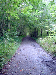
The Sugar River Rail Trail runs 9 miles from Newport, NH, to Claremont, NH, and passes through two railroad covered bridges. Start downtown historic Newport in the municipal parking lot. In less than a mile you are out of downtown and riding through rural areas. There are a couple fairly quiet road crossings on the first half of the trail and then you cross under route 11/103. Soon after, you come to the first of two taller than normal covered bridges designed for trains to pass through. The second bridge is less then a mile further down. The trail continues for a couple more miles into Claremont but it may be temporarily closed due to construction near the second bridge. Return the way you came for an 18 mile ride. The trail surface, in some areas, is softer dirt than many other trails making it best for bikes with wider tires. You can find a trial map at http://www.nhstateparks.org/explore/bureau-of-trails/sugar-river-recreational-trail.aspx.
Honeymoon in the Scottish Highlands Part 2
September 28, 2005
The flight to London took 5 ½ hours at 6:15 PM our time to 4:45 AM London time. We tried to sleep but neither of us got much. I watched Sahara and Sarah watched The Interpreter.
Getting between terminals and through security again at Heathrow took quite a while. We think we went through customs there but we’re not sure. We then had another 1½ hour flight up to Edinburgh. We got in around 8:30 Monday morning. Everyone who began their flight in a non-EU country picked up their baggage on a separate carousel than everyone else. But no one was there to check it or ask us if we had anything can claim. There was a sign next to a phone on the wall that said if you have anything to claim it up this phone. Sarah picked it up to ask a question about my corsage that she had with her but no one answered it.
We picked up our rental car – a subcompact Mercedes. My first experience driving on the left was out of the parking lot into a roundabout in Monday morning rush hour traffic! I rubbed the wheels against the curb because I kept misjudging how much of the car was to the left of me. We planned to drive straight into the city to a car park near Edinburgh Castle. However, that’s not quite what happened. It was Monday morning rush hour traffic. I got in a turn-only lane and there was too much traffic to change my mind. We thought we’d swing around the block and be fine.
An hour and ½ later, we found ourselves at a park and ride outside the city – practically back at the airport. For £2.30 each, we got all day bus passes. Unfortunately we left the camera in the car.
We toured Edinburgh Castle and walked the Royal Mile. We stopped in some of the shops along the way. We also took a short detour to go to Greyfrair’s cemetery to see the statue of Greyfrair’s Bobby. That’s a dog whose master was buried in the cemetery. The dog sat by his master’s grave every day for years until he died. We both dozed on the bus ride back to the car. The drive to the Inchview Hotel was about 20 stressful minutes in on and off rain. The weather during the day had been pretty good. But it was very windy on the Royal Mile.
Sarah’s brother called ahead to arrange for us to have dinner in the hotel restaurant. That was great because we were so tired and tired of driving! We were both nearly falling asleep at the table at 8:00 PM. We went to sleep early and got up around 7:30.
It was sunny but 20 minutes later it was raining. That’s how most of the day went. We had breakfast at the hotel and then headed north. When we got to Pitlochry, we checked out the Pitlochry Festival Theatre and then visited a fish ladder and had a light lunch. We found a nice walking path along the river. There were a few historic sites including where someone famous had been killed and the Soldier’s Leap where an English soldier jumped 20 feet or so across the river while running from Scottish Jacobites.
Tonight we are staying at the Homewood House B&B in Kingussie. After checking in, we drove past some of the sites used in the Monarch of the Glen TV series including the manor house. Sarah drove for the first time. She did OK but was quite stressed. I’m starting to get comfortable driving. We had dinner at the Tipsy Laird pub and are having another early night. As I write this, Sarah is reading tour books for ideas for tomorrow.
Adventure of the Week – Hike Mount Monadnock
Mount Monadnock literally defines southwestern New Hampshire (aka the Monadnock Region). It is said to be one of the most climbed mountains in the world. I have climbed it at least a dozen times ranging from early spring through autumn on a variety of its many trails including the morning of my wedding which was held in view of the mountain. The White Arrow Trail is the easiest route up the mountain going past the site of the former Halfway House hotel. Even that trail gets a little tough near the top. The longest trail is said to be the Pumpelly Trail at over 4 miles one way. My favorite route is one I found on a local activities brochure at Eastern Mountain Sports (whose headquarters is 15 miles north) when I first moved to the area 20 years ago. Start at the Old Toll Road parking area. Half way to the Halfway House site, turn right onto Parker Trail to Cliff Walk which brings you to Bald Rock, a lower peak. From here, you’ll have a good view of the summit and the surrounding valley. Take the Smith Connecting Link to the White Cross Trail and follow that to the summit. Take some time to rest and take in the spectacular 360 degree views of mountains, lakes, farms, villages, and, on a clear day, the skyscrapers of Boston. Return to the parking lot by way of the White Arrow Trail. Plan for 5 to 6 hours taking this route. While you can reach the summit and return to your car in under two hours by a more direct route, this route is more peaceful giving you a better sense of what Henry David Thoreau might have experienced when he climbed the mountain in the mid-1800s.
Adventure of the Week – Bike the Norwottuck Rail Trail
Do you wish you would bike more? Don’t like climbing steep hills? Don’t like sharing the road with cars and trucks? Check out some rail trails. There are a lot of former railroad tracks turned multi-use trails around the country including many great trails throughout New England. Because they were designed for trains, you know they won’t be very steep. In most cases, you won’t find any motorized vehicles although some are open to ATVs. I enjoy the historic aspect knowing the trails have been used for a hundred or more years. Sometimes there are reminders of the rail line along the way – old depots, mile markers, and more.
One pleasant trail is the 11 mile Norwottuck Rail Trail from Northampton to Hadley, Amherst, and into Belchertown in Massachusetts. The surface of rail trails varies from trail to trail but the Norwottuck trail is nicely paved. This trail goes from in-town to passing along active farm fields, past the Hadley Mall and Amherst College and through wooded areas – a little of everything. There are even a couple places to stop for an ice cream along the way. Some sections of the trail (mostly near Northhampton) get a lot of use on sunny summer weekends. Because of the pavement and gentle elevation changes, you’ll find you can bike farther on this trail than on rougher trails for hilly roads.
You can find more information and a trail map at http://www.mass.gov/eea/agencies/dcr/massparks/region-west/norwottuck-rail-trail.html.
Adventure of the Week – Hike the Stowe Pinnacle Trail
The Stowe, Vermont, area is another place we try to get to a couple times a year. There are adventures to be had in every season. In the summer and fall, the Stowe Pinnacle Trail offers some great views of the Green Mountains including Camel’s Hump, Mt. Mansfield, and the village. This is a short but tough trail taking a couple hours to get up and back down the 2.8 mile trail. When you are huffing and puffing just know you have some incredible views waiting for you at the top. If you like covered bridges, be sure to check out the Gold Brook Covered Bridge just off Stowe Hollow Road on (what else) Covered Bridge Road after your hike.
Adventure of the Week – Paddling or Tubing the Saco River
A friend recently went tubing down the Saco River and reminded me of the time my wife and I joined my brother’s family on a canoe trip. We all tented out at Woodland Acres Campground in Brownfield, Maine, Friday night. The next morning, a shuttle van with trailer came through the campground picking up canoes while we ate breakfast. We then boarded the van for the drive about 10 miles up river where we all put in for the ride back downriver to the campground. It was mostly a pretty casual float down the river with one very short section of “white water”. You could portage around it but all you really had to do was just let the current take you through. We stopped a few times to stretch our legs and to eat our packed lunch. When we got back to the campground, we left our canoes on the shore and they were eventually delivered back to our campsites. There are several canoe, kayak, and tubing rental places along the Saco River in New Hampshire and Maine.
Honeymoon in the Scottish Highlands Part 1
I’m starting another new series today – excerpts from our Adventure Journal. Most of the early dates with my wife were hikes, cross-country skiing, and the like. Once we got married, we planned to go on plenty more adventures together so we bought a journal to be a souvenir of all the places we’d go and the sights we’d see. That was nine years ago this month. We’re still going on adventures together (some big, some small). We’re a third of the way through volume two of our Adventure Journal. About once a month, I’ll post an excerpt from the journal perhaps to inspire you to set sail on new adventures.
Today’s excerpt is from the first entry in the journal the day after our wedding written on our flight to our honeymoon in the Scottish Highlands.
September 25, 2005
And so the adventure begins! Sarah and I were married in a small ceremony at her parents’ house in Sharon, New Hampshire, yesterday. The weather was perfect and we were surrounded by friends and family members. After the reception, Sarah’s college friend Liz drove us to Cambridge, MA, where her other college friends chipped in to put us up in the Hyatt Regency for the night. It was a very nice suite overlooking the Charles River and Boston.
After breakfast, we spent five hours wandering around Boston and Cambridge before taking a taxi to the airport. The weather was very nice until noon and then cloudy and cool in the afternoon. We got through security and checking in with in 20 minutes. We’re now on our way to the Scottish Highlands.
Adventure of the Week – Biking the Carriage Roads at Acadia National Park
Sarah and I try to visit Acadia National Park about once a year and always bring our bikes. There are 45 miles of carriage roads around the park thanks to John D. Rockefeller Jr. You may even see a Rockefeller driving his carriage along the roads today. Most of the carriage roads are open to horses, horse-drawn carriages, bikes, and pedestrians while a few of the roads exclude bike use. The carriage roads are wide, well maintained, and well marked. Because they were designed for horse-drawn carriages, they are not too steep (of course “too steep” is a relative term). I have been on all but a couple miles of the roads walking, biking, snowshoeing, and cross-country skiing.
One of my favorite bike rides is around Witch Hole Pond starting from signpost 5 on Duck Brook Road. This area tends to be quieter than other parts of the park.
For a big multi-hour adventure, you can take the route I did with my cousins 10 years ago. We started at the visitor center, past Witch Hole Pond, down to Eagle Lake, on to Aunt Betty Pond, then climbed much of the way up Sargent Mountain to the highest point on the carriage roads and back to the visitor center. I believe that route took three to four hours including a couple rest stops to take in the views. We saw a young fox on the path that day and I have seen deer along the carriage roads many times.
You can find a map of the carriage roads on the Acadia National Park website at http://www.nps.gov/acad/planyourvisit/upload/CRUMmap.pdf.
Adventure of the Week: Green Mountain Adventure Challenge
I’m starting a new weekly series of posts suggesting adventures throughout New England (and occasionally beyond). Adventures may range from pleasant strolls to challenging bike rides and hikes. Every adventure I’ll suggest is one I have done myself – often with my wife, other relatives, and/or friends.
First up – the Green Mountain Adventure Challenge in West Dover, Vermont. This is the third year of the challenge and the second year my wife and I participated. We look forward to many more. Last year’s was a lot like the Nicholas Cage movie “National Treasure” – one clue lead to another clue which lead to another clue each requiring hikes or other travel around the West Dover area. This year’s challenge was a little different but still a lot of fun. A portion of the registration fee goes to cancer care and research. And it’s a great way to see some of the lesser known parts of the area and challenge your body and your brain. There’s still time to participate in the 2014 Challenge through Labor Day weekend. Many teams have completed the challenge in roughly two days.
Learn more about the Green Mountain Adventure challenge here: http://www.greenmountainvermont.com/green-mountain-adventure-challenge.html/
OM&M on GoShopNH.com
Of Moose & Mountain gear is now available on GoShopNH.com. A few t-shirt designs, some oval Euro-style decals, and, of course, the Guide to Understanding New Hampshire Expressions postcards and posters are now all available through the GoShopNH.com website. All of these items were designed by Of Moose & Mountain in Westmoreland, New Hampshire. The items were all produced through local Keene print shops. Check it out today to see OM&M designs and several other products from New Hampshire artisans.